 “Wayfarer, there is no path, you make the path as you go.”
|
|


| English | Español | Deutsch | Français | Nederlands |
THE COUNTRY
- Why Ecuador?
- Slide Show
THE BOOK
- Foreword
- Preface
- Acknowledgments
- Table of Contents
- Trek Summaries
- Index
- About the Authors
- About the Publisher
A SAMPLE TREK
- Overview
- Route Description
- Topographic Map
- Elevation Profile
HOW TO BUY
THE BOOK
UPDATES
FEEDBACK
LINKS
CONTACT US
- The Authors
- The Publisher
© 2002-07 Kunstaetter
(From Chapter 2)
Imagine! A country where the land is higher than the clouds.
- Yoel Nimelman, an astonished immigrant to Ecuador
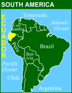
Ecuador is located in the northwest of South America; it lies along the Pacific coast and the equator. It is one of the smallest nations of the continent, with a surface area of approximately 270,000 square kilometers (104,000 square miles). Its neighbors are Colombia to the north and Peru to the south.
The principal topographic feature of the country is the Andes, a massive mountainous spine that runs from north to south. The Andes Mountains divide the Ecuadorean mainland into three regions, from west to east: the Pacific coast, the highlands, and the Amazon basin. A fourth geographic region is made up of the Galápagos Islands, situated 1000 kilometers (620 miles) offshore (directly along the equator). Ecuador is divided into twenty-two provinces, which in turn are subdivided into cantons and parishes for local administration.
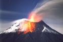
Andean Highlands. Two roughly parallel ranges of the Andes, connected by transverse ridges, form the Ecuadorean highlands known as La Sierra. In the northern Sierra, ten snowcapped volcanic summits tower more than 5000 meters (16,500 feet) above sea level. These volcanoes are set some distance apart from one another, each majestically dominating its own territory. In the southern Sierra the mountains are older, lower, more eroded, and nonvolcanic, resulting in a confused topography of bare sculpted peaks and deeply incised valleys.
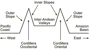
The Ecuadorean geographer Dr. Nelson Gómez describes the high Andes as a world of striking contrasts: "massive glaciers on the equator, snow and volcanic steam, dense fog and brilliant sunshine, severe cold and intense heat." The two main ranges of the Andes are the Cordillera Occidental (the western range) and the Cordillera Oriental (the eastern range). Between them lies a series of gentle green valleys between 2000 and 3000 meters (6500 and 10,000 feet) above sea level. These inter-Andean valleys are densely populated and intensively cultivated right up the mountain slopes, producing fruits, vegetables, grains, and dairy products.
A wilder landscape is to be found on the outer slopes of the Andes, which are covered with cloud forests known as ceja andina (eyebrows of the Andes). They are perpetually shrouded in the mists that rise from the tropical lowlands toward the icy mountaintops.
Pacific Coast. The coastal region, known as La Costa, is a broad alluvial plain drained by several rivers, including the Guayas (the largest river on the west coast of South America). Much of La Costa is densely populated and given over to large-scale agriculture, with corporate enterprises producing bananas and shrimp for the export market as well as other crops for local consumption.
Amazon Basin. The eastern lowlands, known as El Oriente, are part of the enormous Amazon River basin, which covers much of tropical South America. Low mountain ranges at the foot of the Andes, tropical rainforest, and large navigable rivers to the east are the principal geographic features of continental Ecuador's least densely populated region.
Galápagos Islands. These islands of volcanic origin, independent from the mainland, sit near the junction of the Nazca and Cocos tectonic plates. There are eight main islands, six smaller islands, and many islets spread over a large expanse of ocean. Since trekking is not permitted in Galápagos, we will not describe them further in this book.