 “Wayfarer, there is no path, you make the path as you go.”
|
|


| English | Español | Deutsch | Français | Nederlands |
THE COUNTRY
- Why Ecuador?
- Slide Show
THE BOOK
- Foreword
- Preface
- Acknowledgments
- Table of Contents
- Trek Summaries
- Index
- About the Authors
- About the Publisher
A SAMPLE TREK
- Overview
- Route Description
- Topographic Map
- Elevation Profile
HOW TO BUY
THE BOOK
UPDATES
FEEDBACK
LINKS
CONTACT US
- The Authors
- The Publisher
© 2002-07 Kunstaetter
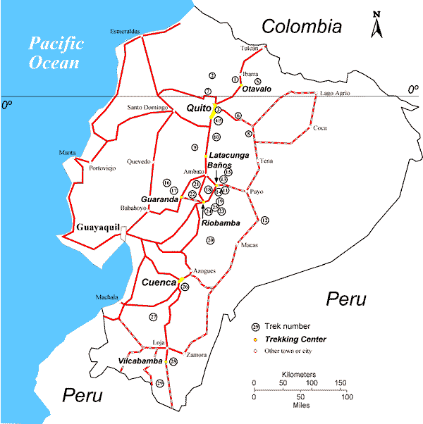
| Trek Number |
Trek Name (Center) | Distance (km) | Elevation (m) | Days |
|
|
||||
| Very Easy | ||||
| 3 | Parque Metropolitano (Quito) | 5 | 2900-3050 | 2 hrs |
| Easy | ||||
| 1 | Guinea-Pig Lake (Otavalo) | 12 | 3050-3450 | 1 |
| 4 | Pasochoa Reserve (Quito) | 13 | 2800-3950 | 1 |
| 5 | Pasochoa Summit (Quito) | 9 | 3300-4200 | 1 |
| 6 | Papallacta (Quito) | 8 | 3300-3500 | 1 |
| 7 | Toucan Trail (Quito) | 16 | 1200-3000 | 1-2 |
| 11 | Valley of the Waterfalls (Baños) | 8 | 1550-1800 | 1 |
| 16 | Great Cascade Trail (Guaranda) | 20 | 900-3750 | 2-3 |
| 18 | Volcano Watching (Riobamba) | 15 | 2800-3900 | 2-3 |
| 26 | Inca Trails (Cuenca) | 15 | 2700-3100 | 1 |
| Moderately Difficult | ||||
| 8 | Guacamayos Trail (Quito) | 10 | 1350-2200 | 1-2 |
| 9 | Hostel Hopping to Quilotoa (Latacunga) | 25 | 2650-3900 | 2-3 |
| 10 | Across Rumiñahui (Latacunga) | 20 | 3000-4200 | 2 |
| 12 | Cave of the Oilbirds (Baños) | 17 | 650-800 | 2-3 |
| 17 | Forgotten Footsteps (Guaranda) | 15 | 1200-3300 | 2-3 |
| 19 | Crater of El Altar (Riobamba) | 20 | 3100-4300 | 3-4 |
| 20 | Atillo and Osogoche Lakes (Riobamba) | 22 | 3500-4200 | 2-3 |
| 21 | Vicuña Trail (Riobamba) | 22 | 3550-4400 | 2-3 |
| 22 | Royal Road (Riobamba) | 33 | 2600-4250 | 3-4 |
| 28 | Natural High (Vilcabamba) | 30 | 1600-3600 | 4-5 |
| Difficult | ||||
| 2 | Ecuador's Chocó (Otavalo) | 45-65 | 600-2100 | 4-6 |
| S (sample) | Fishermen's Lakes (Otavalo) | 25 | 2900-3950 | 5-6 |
| 13 | Tapir Trail (Baños) | 14 | 2200-3700 | 3-4 |
| 14 | Around Tungurahua (Baños) | 25 | 1700-3700 | 4-5 |
| 23 | Hot Springs in the Cloud Forest (Riobamba) | 54 | 2850-4000 | 5-7 |
| 24 | Black Rock of Cubillines (Riobamba) | 23 | 3150-4450 | 4-5 |
| 25 | High Lakes and Ridges (Riobamba) | 45 | 3100-4600 | 5-6 |
| 27 | Gold-Rush Trail (Cuenca) | 65 | 1100-3700 | 5-7 |
| 29 | Pass of the Winds (Vilcabamba) | 52 | 1200-3600 | 4-6 |
| Very Difficult | ||||
| 15 | The Llanganates Experience (Baños) | 35 | 3350-4200 | 7-14 |