 “Wayfarer, there is no path, you make the path as you go.”
|
|


| English | Español | Deutsch | Français | Nederlands |
THE COUNTRY
- Why Ecuador?
- Slide Show
THE BOOK
- Foreword
- Preface
- Acknowledgments
- Table of Contents
- Trek Summaries
- Index
- About the Authors
- About the Publisher
A SAMPLE TREK
- Overview
- Route Description
- Topographic Map
- Elevation Profile
HOW TO BUY
THE BOOK
UPDATES
FEEDBACK
LINKS
CONTACT US
- The Authors
- The Publisher
© 2002-07 Kunstaetter
November 2002
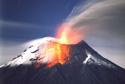
WARNING: See Volcanic Activity updates before attempting this trek.
Trek 14: Around Tungurahua |
|
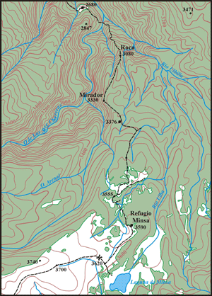
Aerial photo of the route north of Laguna Minsas. (Sketch: Günter Schmudlach) |
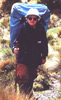
Günter Schmudlach of Switzerland, author of Bergführer Ecuador (Panico Alpinverlag, 2001), did this trek in November 2002. He was among the first people to return to the area since the reactivation of the Tungurahua Volacano in October 1999. We are grateful to Günter for the following notes.
Entry point to the forest. From the shack at Laguna Minsa a confusing network of animal tracks lead to the north. A detailed description would be difficult. The aerial photo (right) shows the correct route. It's highly recommended to explore the correct route the day before. For the owner of a GPS it may help to know, that the entry point lies at the coordinates 790374E, 9837570N (WGS 84; add 259 meters N and 374 meters E to convert to PSAD 56).
Trellis. At the altitude of 3470 meters the track crosses the remnants of a trellis. There is not left more then one stake on the left side and an other on the right side. It's obvious, that years ago there must have been a crop field below this point. In the next section an annoying net of suro covers the track. Some misleading traces guide to the right and end in the bed of the upper west wing Río Ulba. Try to go exactly downhill to find again the right trace. On around 3420 meters the tracks gradually turn to the left (290°). On 3380 m the track crosses a small river, some 80 m later you get to the shack on 3376 m (790284E, 832286N). The shack was used by the park guardian some years ago and is in a miserable state.
 |
|
Map of the route north of Laguna Minsas. (Sketch: Günter Schmudlach) |
Rock steps The closer you come to the altitude of 3100 m, the sharper the ridge becomes. Some 50 meters above a cracked rock, on 3080 meters two 6 meter high vertical rock steps have to be managed. On the left side of the ridge there is a land slide. Some years ago the track might have disappeared due to this landslide. The easiest way to proceed is by rappelling twice over the two steps. It would be possible to climb down, but at least a UIAA III has to be managed. On 3030 meter you get to the cracked rock. On the left side there is a huge rocky bath, which could be used to place a tent. Follow the guts of the ridge, jumping from one rock to the other.
River junction. On 2600 meters, some 50 meters west of the junction between the Río de las Siete Chorreras and the Río Ulba you reach finally the Río de las Siete Chorreras. Cross the river and search for an entry to the forest. Some years ago there must have been a land slide. The soil is rocky, dense bushes cover the area of the land slide. Crawl under the bushes 80 meters uphill (280°) over the area of the landslide. On the right side of the land slide, in a steep area you should find the old track. Following the track you will ascend other 40 meters till you come to the highest point on 2720 meters. The track circulates the ridge of the point 2847 meters (on the IGM 1:50,000 topo map of the year 2000). On 2680 meters finally you come to the first pasture exploited till our days (789545E, 840442N). It's very important to find the old track of the path. Never follow the Río Ulba. The river soon enters a deep canyon, there is no way coming through.
Enjoy your trip!
|
Return to List of Updates |